
The deo tibba base camp trek is one of the most rewarding high-altitude adventures in Himachal Pradesh, offering a perfect blend of alpine meadows, dense forests, glaciers, rivers, moraines, and breathtaking mountain views. For trekkers seeking an unforgettable Himalayan experience, the deo tibba base camp trek stands out as an exceptional choice that combines adventure, scenic beauty, and challenging terrain.
Organized by Broza Adventures, the deo tibba base camp trek takes participants deep into the majestic Pir Panjal Range, where every day reveals new landscapes and unforgettable moments. The deo tibba base camp trek is ideal for experienced trekkers who wish to move beyond beginner routes and explore a more demanding mountain environment.
Located above Jagatsukh village near Manali, the deo tibba base camp trek provides incredible views of Deo Tibba Peak, Indrasan Peak, glaciers, snowfields, and pristine Himalayan valleys. Whether you are planning your first high-altitude adventure or preparing for bigger mountaineering objectives, the deo tibba base camp trek delivers an incredible learning and exploration opportunity.
Many trekkers who complete the beas kund trek, hampta pass trek, rani sui lake trek, or patalsu peak trek often choose the deo tibba base camp trek as their next major Himalayan challenge. The route serves as an excellent progression toward advanced expeditions such as the friendship peak expedition, yunam peak expedition, and hanuman tibba expedition.
Broza Adventures has established itself as one of the most trusted trekking and expedition operators in Himachal Pradesh. Choosing the deo tibba base camp trek with Broza Adventures ensures professional guidance, safety-focused operations, and memorable trekking experiences.
When you book the deo tibba base camp trek with Broza Adventures, you gain access to a team that understands the terrain, weather conditions, and safety requirements of the region.
The deo tibba base camp trek offers a variety of attractions that make it one of the most sought-after trekking experiences in Himachal Pradesh.
Every section of the deo tibba base camp trek introduces trekkers to new Himalayan scenery. The diversity of terrain encountered during the deo tibba base camp trek makes it significantly more exciting than many conventional trekking routes.
The deo tibba base camp trek is located in the Kullu district of Himachal Pradesh. The trek approaches the magnificent Deo Tibba massif through scenic valleys, forests, and alpine terrain before reaching the spectacular base camp area.
The name "Deo Tibba" translates to "Hill of the Gods," and local legends suggest that the summit was a sacred gathering place for deities. This spiritual significance adds another dimension to the deo tibba base camp trek, making it appealing not only to adventure enthusiasts but also to travelers interested in local culture and mythology.
The deo tibba base camp trek attracts trekkers from across India and around the world because of its unique combination of wilderness, altitude, and mountain scenery.
The deo tibba base camp trek differs from many Himalayan treks because it offers a true expedition-like atmosphere. Instead of crowded trails, trekkers encounter remote valleys, pristine landscapes, and authentic mountain experiences.
Unlike shorter treks, the deo tibba base camp trek allows participants to spend several days acclimatizing and exploring high-altitude terrain. This extended journey provides a deeper connection with the mountains.
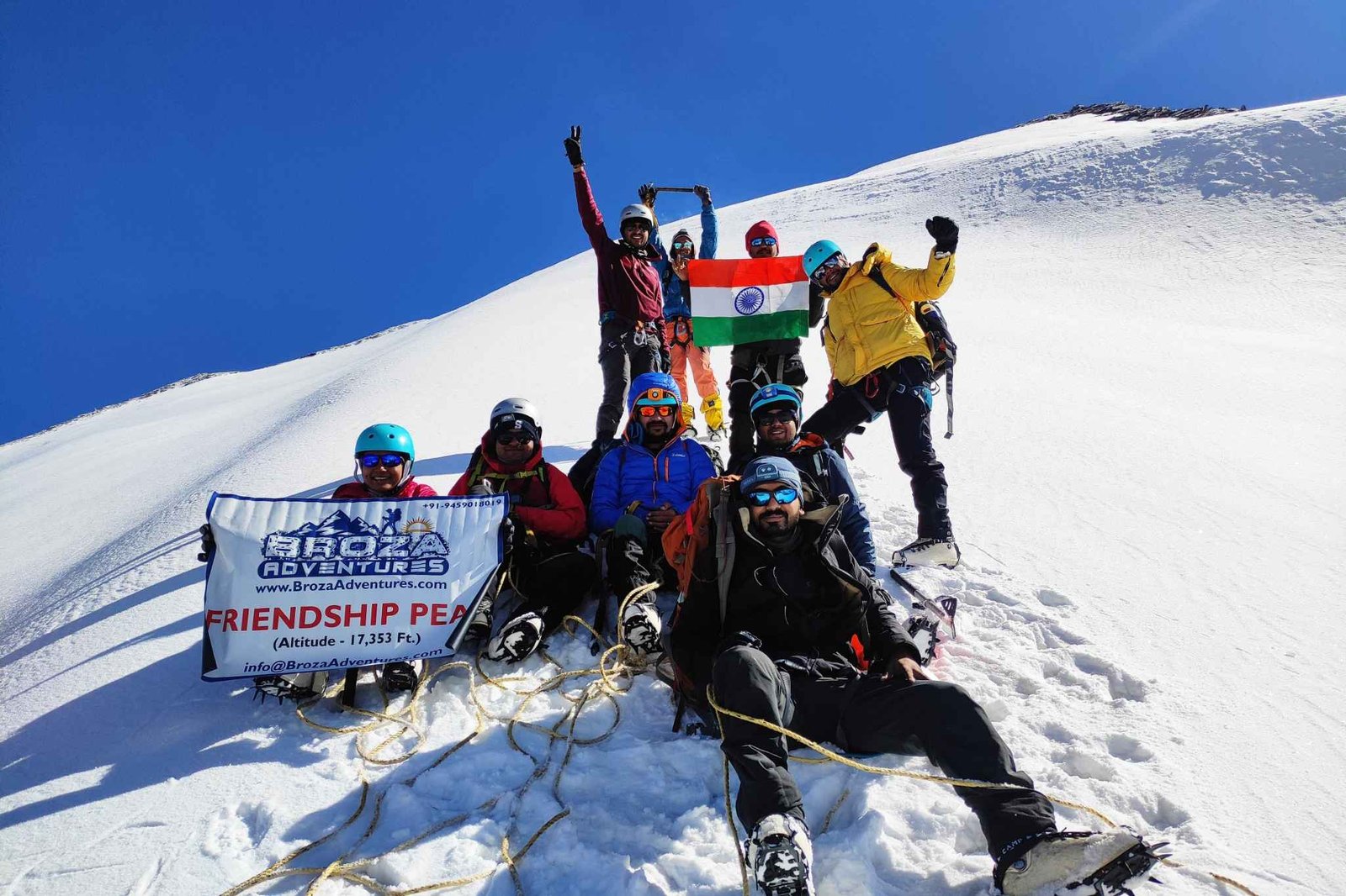
Many mountaineers use the deo tibba base camp trek as training before attempting the friendship peak expedition, yunam peak expedition, or shinkun east expedition.
Choosing the right season is essential for enjoying the deo tibba base camp trek.
The deo tibba base camp trek during early summer offers lingering snowfields, pleasant temperatures, and excellent mountain visibility.
The deo tibba base camp trek becomes greener after the monsoon period. Meadows are vibrant, and streams flow abundantly.
Many experienced trekkers consider this the best season for the deo tibba base camp trek because of stable weather conditions and clear Himalayan views.
Seasonal Advantages
The beauty of the deo tibba base camp trek changes with every season, making each departure unique.
The deo tibba base camp trek is classified as a moderate to challenging trek. Participants should have prior trekking experience before attempting the deo tibba base camp trek.
The deo tibba base camp trek involves steep ascents, rocky sections, glacier terrain, and high-altitude camping. Proper preparation significantly improves the trekking experience.
One of the greatest attractions of the deo tibba base camp trek is the variety of landscapes and mountain views encountered throughout the route.
The deo tibba base camp trek provides endless opportunities for landscape photography and nature observation.
Related Treks and Expeditions Around Manali
Trekkers who enjoy the deo tibba base camp trek often explore additional adventures offered by Broza Adventures.
Many trekkers complete the deo tibba base camp trek before progressing to these advanced Himalayan adventures.
The carefully planned schedule makes the deo tibba base camp trek safe and enjoyable while allowing proper acclimatization.
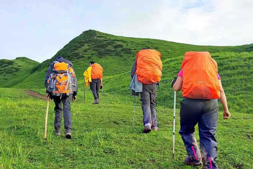
The deo tibba base camp trek begins with a scenic drive from Manali to Khanol. During this journey, trekkers pass through beautiful mountain villages, forests, and valleys that showcase the natural beauty of Himachal Pradesh.
Upon reaching Khanol, the trekking section of the deo tibba base camp trek officially starts. The trail gradually climbs through dense oak and deodar forests. Along the route, trekkers encounter beautiful vegetation, herbs, wildflowers, and panoramic mountain views.
Day 1 Highlights
The first day of the deo tibba base camp trek helps participants settle into the mountain environment while enjoying spectacular surroundings.
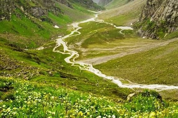
The second day of the deo tibba base camp trek takes trekkers deeper into the valley toward the beautiful Seri meadows. The trail follows the Jagatsukh Nallah and gradually moves through forests before opening into vast alpine landscapes.
As the deo tibba base camp trek progresses, trekkers encounter massive boulders, freshwater streams, and breathtaking meadows. The changing scenery keeps the journey exciting and rewarding.
Day 2 Highlights
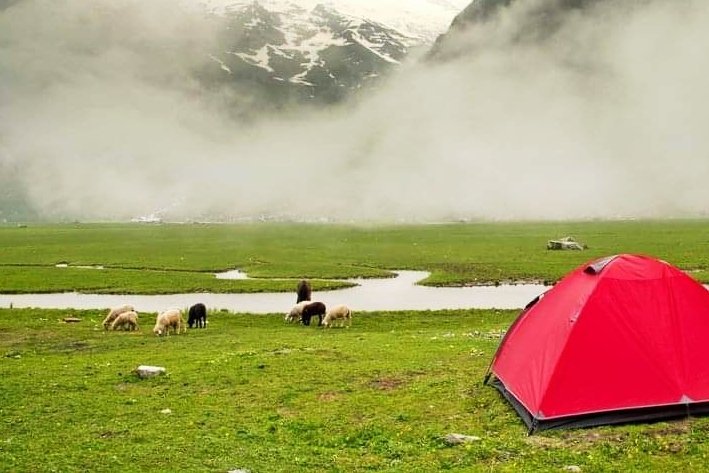
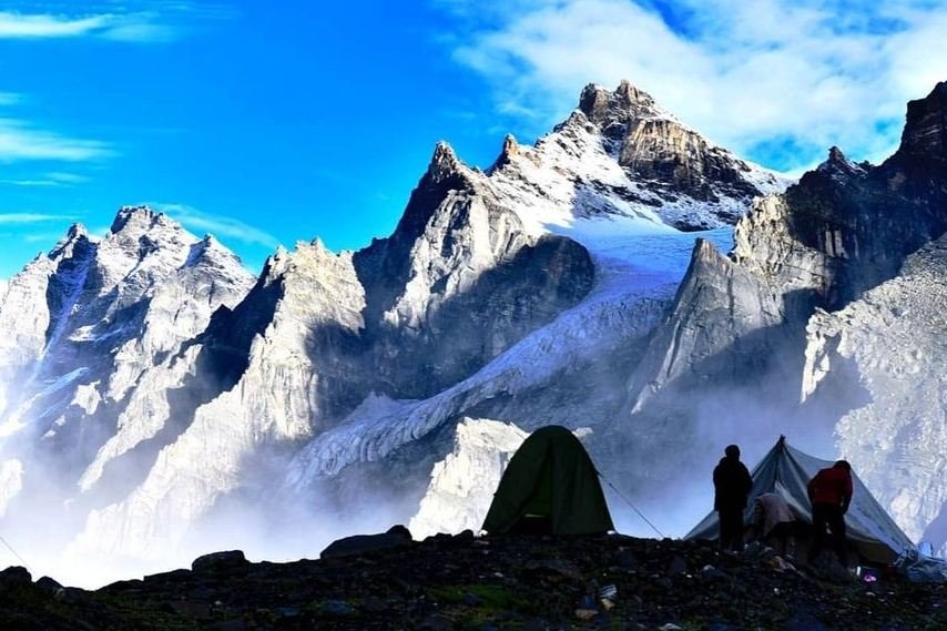
Camping at Seri is among the most memorable experiences of the deo tibba base camp trek because of the magnificent mountain backdrop.
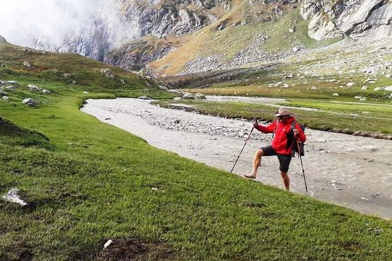
This is one of the most exciting stages of the deo tibba base camp trek. The route follows the river valley before ascending toward the spectacular Tainta Camp area.
Trekkers on the deo tibba base camp trek cross moraines, navigate rocky sections, and gain significant altitude. Upon reaching base camp, the scenery transforms dramatically into a rugged high-altitude environment dominated by glaciers and towering peaks.
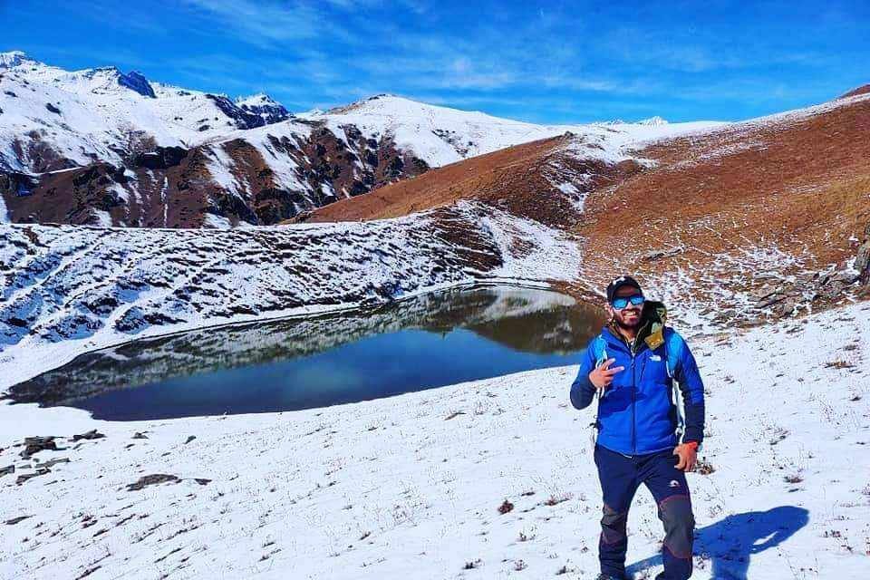
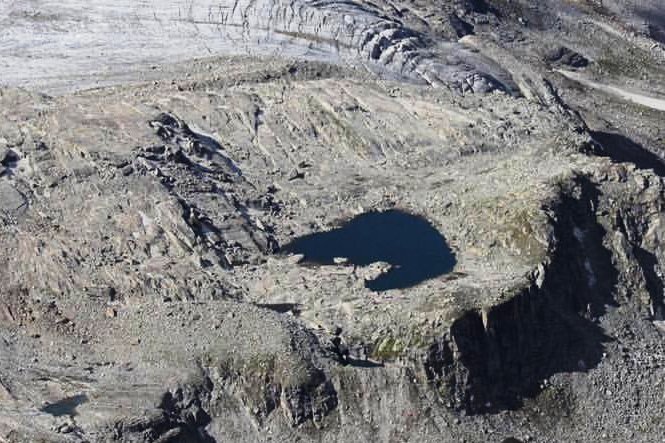
A short excursion toward Chota Chandratal often becomes a highlight of the deo tibba base camp trek, offering incredible views and photography opportunities.
Day 3 Highlights
The arrival at base camp marks a major milestone of the deo tibba base camp trek and provides unforgettable Himalayan scenery.
The deo tibba base camp trek includes an important acclimatization day to help trekkers adapt to higher altitudes. This day is essential for safety and overall success.
Participants on the deo tibba base camp trek spend time exploring nearby areas, practicing mountain skills, and attending briefing sessions conducted by experienced guides.
Activities
This acclimatization day significantly improves the experience of the deo tibba base camp trek and prepares trekkers for higher camps.
The deo tibba base camp trek now enters a more expedition-style phase. Trekkers carry equipment toward Camp 1 and then return to lower altitude for overnight rest.
This strategy helps participants adjust gradually while preparing for upcoming climbs during the deo tibba base camp trek.
Day 5 Highlights
The load ferry process is a vital component of the deo tibba base camp trek and contributes significantly to safety.
On Day 6, the deo tibba base camp trek advances toward Camp 1. The route follows terrain explored during the previous day's load ferry.
Trekkers move steadily across snow-covered slopes while enjoying increasingly dramatic views. The deo tibba base camp trek becomes more adventurous as altitude increases and the environment grows more alpine.
Day 6 Highlights
The successful completion of Day 6 places trekkers in an excellent position for the next stages of the deo tibba base camp trek.
Day 7 is one of the most thrilling stages of the deo tibba base camp trek. After spending the night at Camp 1, trekkers begin their gradual ascent toward Summit Camp. The route of the deo tibba base camp trek on this day involves traversing snow-covered slopes, glacier sections, and high-altitude terrain that offers a true expedition experience.
As the deo tibba base camp trek gains elevation, panoramic views of surrounding Himalayan peaks become increasingly spectacular. Trekkers witness vast snowfields and rugged mountain landscapes that define the high-altitude character of the deo tibba base camp trek.
The first section of the deo tibba base camp trek includes moderate climbing, while the later portion becomes steeper and requires careful footing. Proper pacing is essential during the deo tibba base camp trek because altitude gain becomes more noticeable at this stage.
Day 7 Highlights
Camping at Summit Camp is one of the most memorable experiences of the deo tibba base camp trek. The remote surroundings, silence of the mountains, and clear night skies make this stage unforgettable.
The deo tibba base camp trek continues with mountain activities around Summit Camp and further acclimatization. This stage of the deo tibba base camp trek helps trekkers become comfortable with snow travel and higher elevations.
During the deo tibba base camp trek, participants learn valuable mountain skills while exploring the terrain around Summit Camp. Guides provide safety instructions and practical tips that are useful for future expeditions.
The deo tibba base camp trek at this altitude offers incredible opportunities to appreciate the grandeur of the Pir Panjal Range. Every direction reveals snow-capped ridges, glaciers, and dramatic mountain scenery.
Day 8 Highlights
This section of the deo tibba base camp trek provides valuable exposure to expedition-style trekking and mountaineering environments.
Day 9 serves as the summit attempt or buffer day of the deo tibba base camp trek. Weather conditions in the Himalayas can change quickly, which is why the deo tibba base camp trek includes an additional day for flexibility and safety.
The summit route associated with the deo tibba base camp trek involves traversing snow slopes and carefully navigating high-altitude terrain. Participants experience some of the most dramatic mountain scenery available during the deo tibba base camp trek.
As trekkers ascend during the deo tibba base camp trek, breathtaking views of neighboring Himalayan peaks emerge. The surrounding landscape showcases the immense beauty of Himachal Pradesh's mountain wilderness.
Day 9 Highlights
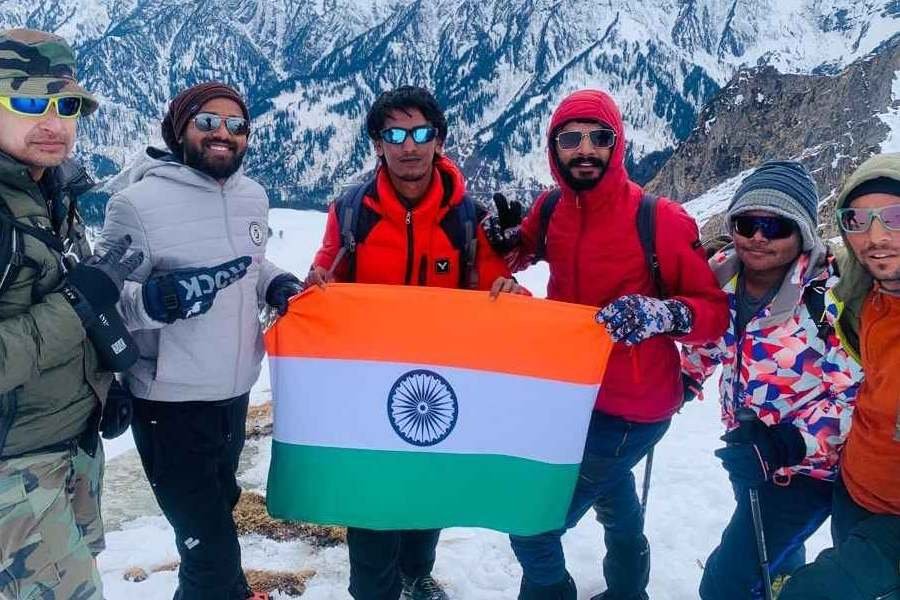
The summit day represents a major achievement for participants completing the deo tibba base camp trek and creates memories that last a lifetime.
After the high-altitude phase of the deo tibba base camp trek, trekkers begin descending toward base camp. The return journey during the deo tibba base camp trek allows participants to revisit familiar landscapes while enjoying a more relaxed pace.
Descending on the deo tibba base camp trek requires careful foot placement, particularly on rocky and snowy sections. Although downhill movement is generally easier, maintaining focus remains important throughout the deo tibba base camp trek.
Day 10 Highlights
The return to base camp marks another important milestone of the deo tibba base camp trek and offers a chance to celebrate the accomplishments achieved so far.
The deo tibba base camp trek continues with a long but rewarding descent toward Chika. As trekkers lose altitude during the deo tibba base camp trek, vegetation gradually returns and the landscape transforms from alpine wilderness back into lush valleys.
The route of the deo tibba base camp trek passes through scenic meadows, streams, and rocky sections that appeared very different during the ascent. Many participants discover new perspectives on the beauty of the deo tibba base camp trek while descending.
Day 11 Highlights
The final camping night of the deo tibba base camp trek is often filled with stories, celebrations, and reflections on the incredible journey.
The final day of the deo tibba base camp trek begins with a pleasant descent from Chika to Khanol. The trail provides one last opportunity to appreciate the forests and valleys that characterize the lower sections of the deo tibba base camp trek.
Upon reaching Khanol, participants complete the trekking portion of the deo tibba base camp trek and begin the drive back to Manali. The journey concludes with unforgettable memories and a deep appreciation for the Himalayas.
Day 12 Highlights
Successfully finishing the deo tibba base camp trek is an achievement that demonstrates endurance, determination, and a passion for mountain exploration.
When you book the deo tibba base camp trek with Broza Adventures, the following services are included:
Accommodation
Meals
Safety & Support
Logistics
Equipment Provided
The inclusion package ensures that participants can enjoy the deo tibba base camp trek with confidence and convenience.
Packing correctly is essential for a successful deo tibba base camp trek.
Clothing
Headwear & Hand Protection
Footwear
Essential Accessories
Hydration
Trekking Gear
Personal Items
Carrying the correct gear significantly improves comfort and safety during the deo tibba base camp trek.
Thousands of trekkers trust Broza Adventures for Himalayan journeys because of our commitment to safety, professionalism, and memorable experiences.
Advantages of Trekking with Us
Our Commitment
The deo tibba base camp trek with Broza Adventures is designed to deliver a safe, enjoyable, and unforgettable Himalayan experience
The deo tibba base camp trek reaches high-altitude regions above 4,000 meters and offers exceptional mountain views.
Yes, the deo tibba base camp trek is considered moderate to challenging and is best suited for trekkers with prior experience.
The ideal months for the deo tibba base camp trek are June to October.
The standard deo tibba base camp trek itinerary generally takes 12 days.
Previous trekking experience is highly recommended for the deo tibba base camp trek.
Yes, the deo tibba base camp trek includes acclimatization days for safety.
Fit beginners with trekking experience may attempt the deo tibba base camp trek, though preparation is essential.
The deo tibba base camp trek offers views of Deo Tibba, Indrasan, and surrounding Himalayan peaks.
Yes, camping is a major component of the deo tibba base camp trek experience.
Good cardiovascular endurance and leg strength are important for the deo tibba base camp trek.
Yes, the deo tibba base camp trek is excellent preparation for advanced Himalayan expeditions.
Treks like the beas kund trek, hampta pass trek, and patalsu peak trek provide useful preparation.
The deo tibba base camp trek usually starts from Manali, followed by a drive to Khanol and then the trek begins.
Yes, permits and local permissions are required for the deo tibba base camp trek, and Broza Adventures arranges them.
Yes, the deo tibba base camp trek has multiple water sources, though trekkers should carry sufficient water at higher camps.
Accommodation during the deo tibba base camp trek is primarily in alpine tents at designated campsites.
Since the deo tibba base camp trek reaches high elevations, acclimatization is essential to reduce altitude-related risks.
The deo tibba base camp trek reaches elevations above 4,000 meters, depending on the itinerary and camp locations.
Yes, travel and trekking insurance are strongly recommended for the deo tibba base camp trek.
Yes, many essential trekking items can be rented in Manali before starting the deo tibba base camp trek.
Temperatures during the deo tibba base camp trek can drop below freezing at higher camps, especially at night.
Mobile connectivity is limited during the deo tibba base camp trek, especially after leaving lower-altitude settlements.
Many trekkers move on to the friendship peak expedition, yunam peak expedition, or hanuman tibba expedition after completing the deo tibba base camp trek.
Yes, glacier landscapes are among the major attractions of the deo tibba base camp trek.
Absolutely. The deo tibba base camp trek offers forests, meadows, glaciers, rivers, alpine lakes, and snow-clad peaks that are perfect for photography.
The deo tibba base camp trek is much more than a trekking route. The deo tibba base camp trek is a journey through some of the most spectacular landscapes in Himachal Pradesh. Every section of the deo tibba base camp trek introduces trekkers to a new environment, from lush forests and colorful meadows to glaciers and high-altitude snowfields.
For adventure seekers looking to move beyond beginner treks, the deo tibba base camp trek provides the perfect challenge. The deo tibba base camp trek helps trekkers gain confidence, improve endurance, and experience expedition-style trekking in the Himalayas.
The deo tibba base camp trek also serves as an excellent preparation route for larger mountaineering goals. Many climbers complete the deo tibba base camp trek before attempting advanced objectives such as the friendship peak expedition, yunam peak expedition, hanuman tibba expedition, and shinkun east expedition.
Those interested in exploring more of Himachal Pradesh often combine the deo tibba base camp trek with adventures such as Chandratal Lake tour packages, Dev Roopa Trek, hampta pass trek, ghepan lake trek, rani sui lake trek, beas kund trek, Shrikhand Mahadev trek, and chandrakhani pass trek.
Whether your goal is mountain exploration, photography, adventure, or personal achievement, the deo tibba base camp trek delivers an experience that remains unforgettable long after the journey ends.
The deo tibba base camp trek is one of the finest trekking experiences in Himachal Pradesh and continues to attract trekkers seeking adventure, high-altitude landscapes, and authentic Himalayan exploration. From dense forests and alpine meadows to glaciers and breathtaking mountain panoramas, the deo tibba base camp trek offers remarkable diversity throughout the journey.
When you choose Broza Adventures for the deo tibba base camp trek, you benefit from experienced guides, carefully designed itineraries, quality equipment, and a strong focus on safety. Every stage of the deo tibba base camp trek is planned to maximize enjoyment while ensuring proper acclimatization and support.
If you are looking for a Himalayan adventure that combines challenge, beauty, and achievement, the deo tibba base camp trek deserves a place at the top of your trekking bucket list. The memories created during the deo tibba base camp trek will inspire future adventures and deepen your connection with the mountains. Whether you are progressing from the beas kund trek, hampta pass trek, or preparing for the friendship peak expedition, the deo tibba base camp trek stands as an unforgettable experience in the heart of the Himalayas.
Mount Friendshipp Peak in Manali becoming more famous for experience trekkers and beginners, this Expedition wil
View Details